![]() |
| ![]()
![]() |
| ![]()
The portal provides information about the project Historical Atlas of Towns of the Czech Republic, which has presented, since 1995, the development of selected urban settlements in Bohemia, Moravia, and Silesia to both professional and general audiences. The individual volumes document this development through historical maps, vedutas, early photographs, aerial images, as well as reconstruction maps and models accompanied by explanatory texts. Each volume of the atlas is prepared in accordance with the framework guidelines established by the International Commission for the History of Towns. The portal gradually introduces the individual volumes and provides detailed online lists of maps, plans, and illustrations, including the reference codes of the original items held by memory institutions, as well as the imprint and summaries.
For a selected number of towns, map applications have been developed, depending on available financial resources and staffing capacity. Owing to copyright restrictions, the complete cartographic and visual materials contained in the published atlases, including the texts, are not made accessible online.
The atlas is used in the study of the development of urbanization processes in the Czech lands and the history of municipal communities, in heritage conservation, in the active protection, restoration, and landscape planning, as well as in educational and outreach activities, among other areas.
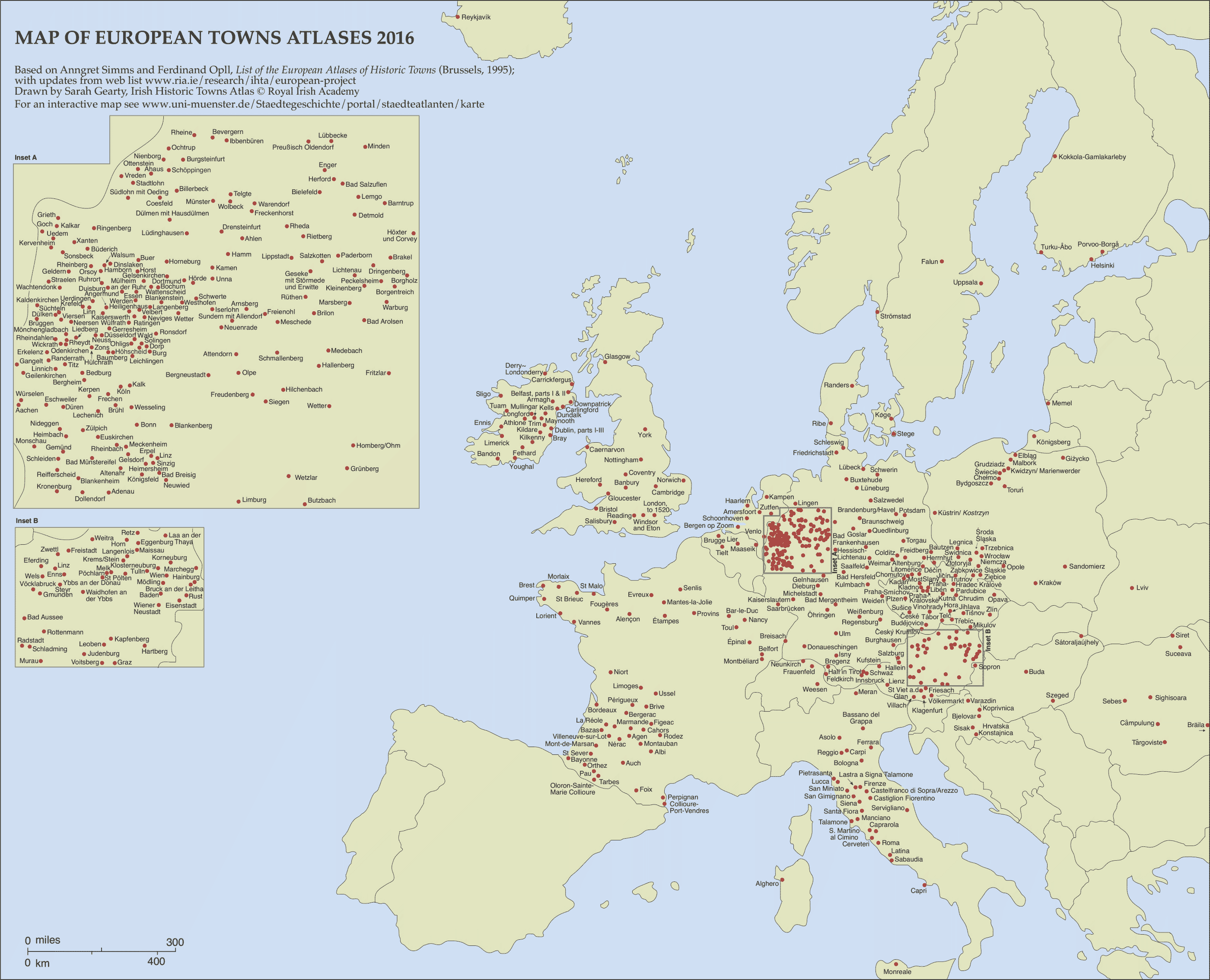
Towns and cities included in the Historic Towns Atlas Europe-wide (by 2016; map by Sarah Gearty, Royal Irish Academy).
Updated interactive distribution map dealing with urban history is available on the website and is run by the Institute for Comparative Urban History, Münster, Germany.
Heritage: Research into New Methodologies and Technologies for the Digitisation, Accessibility, and Use of Old Maps, Plans, Atlases, and Globes (2011–2015); NAKI II No. DG18P02OVV015 Dowry Towns of Bohemian Queens (A Living Component of Historical Awareness and Its Support through the Tools of Historical Geography, Virtual Reality, and Cyberspace); and NAKI III No. DH23P03OVV075 Historic Spa Settlements as a Cultural, Urban, and Landscape-Shaping Phenomenon (2023–2027). In 2016–2018, the project received methodological support from the Centre of Excellence Research Centre for Historical Geography (GA ČR No. P410/12/G113).
Eva Semotanová
Jiří Krejčí
Authors of this website:
Eva Chodějovská, Jiří Krejčí; Stable Land Register elaboration: Tomáš Marek
Web portal administration since 1.1.2017:
Eva Semotanová, Jiří Krejčí
Translations:
Miroslav Košek, Marcela K. Perett, Lucie Vidmar
Logo graphic design:
Zuzana Havelcová
Web design:
Dominik Hrodek