The aim of the Historic Towns Atlas project has been, since 1994, to describe the development of cities and towns in Bohemia, Moravia and Silesia for use by both professionals and the public. It consists of old maps, town views, old photographs, aerial photographs, and thematic (reconstruction) maps and 3D models. The individual volumes are processed within the framework of the rules of the International Commission for the History of Towns, which has been publishing historical atlases of towns since the mid-1950s. So far, more than 520 historic atlases have been issued within involved European countries. The authors of Atlases make use of digital technologies: the so-called core maps can be published on-line and incorporated to the web map portals. This allows for comparing the spatial development of cities across Europe as well as other studies of urban and topographic changes in a particular town/city. The aim of this portal is to provide a reconstruction map, which reflects the respective town/city in the days before the period of industrialization, massive urbanization and other related fundamental changes of landscape that took place in the second half of the 19th century. These gradually uploaded maps are being prepared on the basis of the Compulsory Imperial Imprints of the Stable Land Register (dating back to the period between 1820 and 1840), according to the designed map legend. Besides maps in web applications and the maps at a scale of 1:2 500 in raster format, clicking on the marked point provides basic information about a particular town/city, English and German summaries of the appropriate volume of the Atlas and information on it and access to map applications, which arose in connection with the preparation of the volume of Historic Towns Atlas of the Czech Republic in a respective town/city, but independently and without the application of a uniform methodology (information about the authors are part of the relevant portals). Special attention is paid to Prague.

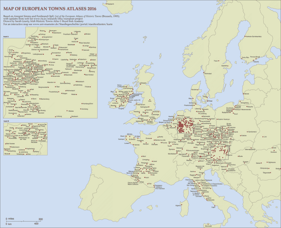
Towns and cities included in the Historic Towns Atlas Europe-wide (by 2016; map by Sarah Gearty, Royal Irish Academy).
Updated interactive distribution map dealing with urban history is available on the website and is run by the Institute for Comparative Urban History, Münster, Germany.
This Web Map Portal builds on grant projects “Historický atlas měst České republiky” (GA ČR 404/94/0883, 404/97/0651, 404/00/1706, 404/03/1081, 404/06/1260, 404/09/0897, 13-11425S), and on a program of applied research and development “Národní kulturní identita” No. DF11P01OVV021: “Kartografické zdroje jako kulturní dědictví. Výzkum nových metodik a technologií digitalizace, zpřístupnění a využití starých map, plánů, atlasů a glóbů.” During 2016, the project is supported by the Research Centre of Excellence, “Výzkumné centrum historické geografie” (GA ČR No. P410/12 /G113). 2018 ‒ 2022 partly by the project “Dowry Towns of Bohemian Queens” (NAKI II, No. DG18P02OVV015) and since 2017 partly by Strategy AV21, Digital Humanities. The portal provides wide access to cartographic sources and reconstruction (thematic) maps and illustrations in the form of a model study of urban landscape changes. Maps and illustrations available on this portal are published with the consent of the respective owners and institutions – legal and private entities –, and the texts with the consent of their authors.
Eva Chodějovská
Eva Semotanová
Jiří Krejčí
Authors of this website:
Eva Chodějovská, Jiří Krejčí; Stable Land Register elaboration: Tomáš Marek
Web portal administration since 1.1.2017:
Eva Semotanová, Jiří Krejčí
Translations:
Miroslav Košek, Marcela K. Perett, Lucie Vidmar
Logo graphic design:
Zuzana Havelcová
Web design:
Dominik Hrodek